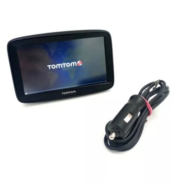
Навігація для IGO Навітел 7 вихід МДП вантажівка
В наявності
Артикул
12281173505
8 450,00 грн.

Navigation for TRUCK TIR Igo Navitel 7 Outlet
7 " HD display 800X480PX LED COLOR glass matrix (TFT) - the touch works like in a smartphone
Висока якість 256 МБ RAM memory
DedicatedARM Cortex A7 processor for GPS navigation
Висока якість GPS / стабільна посилання
High screen brightness / a wide range of colors
блок живлення12 / 24 В / 5V1. 5A
нова оновлена модель Navitel E700 / Win CE розблокована / завантажена Igo Primo
the current Igo Truck Primo map has been uploaded with the possibility of editing the vehicle. Trucks, including ADR, BUS, passenger car and custom settings.
the latest map 2022 April-Q4 2021 IGO-version without Russia
POIs for trucks
Speed cameras | Maps of all of Europe without Russia | Multilingual
Navigation for TRUCK TIR Igo Navitel 7 Outlet
Reverse versions, May show slight signs of useкарти 48 європейських країн
Албанія | Андорра / Австрія / Азербайджан | Білорусь | Бельгія | Боснія і Герцеговина | Болгарія | Хорватія | Кіпр | Чехія | Данія | Естонія | Фінляндія | Франція | Німеччина | Гібралтар | Греція | Угорщина | Ісландія | Ірландія | Італія | Казахстан | Косово | Литва | Латвія | Ліхтенштейн | Люксембург | Македонія | Мальта | Молдова | Монако | Монтенегро | Netherlands | Norway | Poland | Portugal | Romania | San Marino | Сербія | Slovakia | Slovenia | Spain | Sweden | Switzerland | Ukraine | Great Britain | Vatican
версія готова до використання прямо з коробки. Configured IGO Q2 2021
Startup Settings
POI enabled / visible on the map:
If we want to change or add POIS visible on the maps, тоді
Map settings / settings / placemarks
We can also choose from
бізнес / Shops / Banks / Accommodation Medical points / Пристань відпочинок / Спорт / транспорт
Data fields-shown in the lower right corner
If we want to change getting Data fields:
Settings / visual guidance / Data field settings
швидке меню (верхній правий кут)Heavy Start profile:
If we want to change Vehicle parameters:
Settings / Route settings/Truck profile
the biggest advantages of the iGo software
Very clean interface
Extensive програма configuration options
Speed of routing, lots of alternative routes
Unlimited number of waypoints
a largePOI database including POI Premium for heavy goods vehicles is available free of charge
the current base of fixed speed cameras is available free of charge
Safe and error-free driving, lots of valuable information while driving, m.in. Car parks and gas stations on the highway
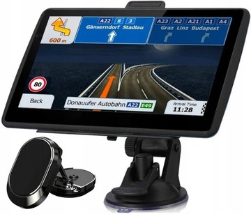
MANEUVER ASSISTANT
There is a box in the top left corner thatdisplays The next maneuver . This could be the next one (turn, roundabout,highway exit, city, street і т.) and its distance from your current position. Маленький значок показує тип наступного маневру, якщо він близький до першого. В іншому випадку, тільки наступний маневр відображається.
TRAFFIC ASSISTANT / the MULTIPLE Band WAY
The Assistant functiondisplays lanes and their directions with small arrows at the bottom of the map. освітлені стріли являють собою Лани, які ви повинні подорожувати. Arrows replace the signs where additional information is available. Signposts are displayed at the top of the map. The color and style of the signposts are similar to the real Ones
VIEW of INTERSECTIONS
As you approach a motorway exit or a complex intersection, instead of a map, a 3D view of the junction will appear, along with the lanes you must follow.
Navigation for TRUCK TIR Igo Primo Navitel 7
the highest quality of components
Navitel E700 is a high-class device with a 7-inch LED display and a glass matrix, with a resolution of 800x480 pixels and an aspect ratio of 16: 9.
The Mstar MSB2531 ARM Cortex-A processor хронометрували at 800 Мгц is responsible for the smooth operation of the device, which allows you to take full advantage of the unlocked Windows CE 6.0 system, and the correct location and strong signal is provided by a multi-channel GPS receiver. the large,256 MB DDR RAM memory also deserves attention. which will ensure high efficiency and stable operation.
Large display
Navitel E700 is a car navigation system with a bright, 7-inch touch screen, made in TFT technology. The equipment uses pre-installed offline maps. The driver can use the device without additional Data transfer charges.
Display
General
Connection options